During any average year, one can expect approximately 11 tropical storms, six hurricanes and two major hurricanes in the Atlantic hurricane season. Many of them stay at sea without causing harm; in fact, they become crucial convective mechanisms for heat transfer in planetary scales.
However, this was not any average year. This was 2005.
After a relatively normal start, the 2005 Atlantic hurricane season picked up its pace during July. The Atlantic Ocean began churning out tropical cyclones at an unprecedented pace: starting with Hurricane Dennis, the season began shattering records for early storm formation. In fact, by the middle of August—the historical peak of hurricane season—the season has already seen the birth of 10 tropical storms. Almost a full "normal" season's worth of activity had already occurred, and we had not reached the halfway mark of the hurricane year. The eleventh storm would enter the United States's collective consciousness in a shroud of infamy. So profound was the storm's effect that its name, Katrina, is etched into a Pantheon of immediately-recognizable calamities alongside atrocities such as Pearl Harbor and 9/11. Katrina instantaneously invokes images of human suffering and government incompetence on such a large scale that it becomes hard to believe that the disaster occurred in a first-world country.
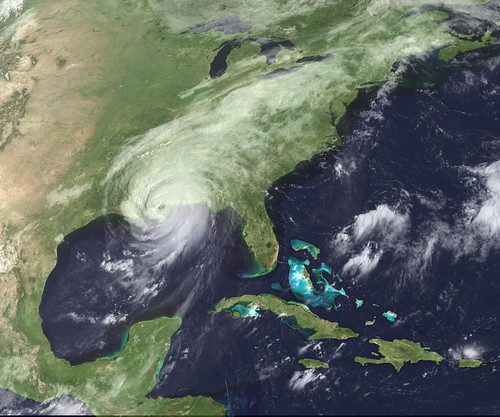
The date is Monday, August 29, 2005. During the previous week, Katrina entered the Gulf of Mexico after a brief flirtation with South Florida—and began its transformation into a true monster immediately afterwards. At 11 p.m. three days ago, the National Hurricane Center began showing that the storm was taking aim at the Mississippi River Delta. At 10 a.m. the next day, the first hurricane watch was issued for the region. Twelve hours later, the watch was upgraded to a warning. Katrina was expected to be a dangerous storm, but overnight on August 28, the forecasters received most unwelcome news from aircraft reconnaissance: The hurricane had intensified into a Category 5 hurricane, the highest classification possible in the Saffir-Simpson scale of hurricane intensity. The storm intensified even further throughout the day, reaching winds of 150 knots (175 mph); these winds would bring ruinous destruction to any unprotected structures or people.
As the clock struck midnight, the outer rainbands began their onslaught on coastal Louisiana and Mississippi. A last-minute eyewall replacement cycle weakened the maximum winds slightly; however, Katrina had grown outward to bring hurricane-force winds over a wide area. At 6:10 CDT, the eye crossed land into Louisiana; after emerging on the other side of the Mississippi delta, Katrina made its final landfall near Mississippi at Category 3 intensity.
At 10:11 a.m. on August 28, the local National Weather Service office in Slidell, Louisiana issued a most ominous of warnings: It warned that "most of the area will be uninhabitable for weeks, perhaps longer," "airborne debris will be widespread... persons, pets and livestock exposed to the winds will face certain death if struck". The warning bulletin has been described as the most chilling in the National Weather Service's history. Unfortunately, the warning was unfortunately prophetic. At least 1,836 people lost their lives as a result of the hurricane and the ensuing floods, making it deadliest tropical cyclone in the United States since 1928. Property damage estimates by the National Hurricane Center rose to $81 billion in 2005 dollars; more recent estimates point that the storm caused up to $125 billion in damage. In either case, the hurricane is the costliest natural disaster in the history of the United States.
Today is August 29, 2010. Five years have passed since the storm devastated the region. Images of the ripped, squalid Superdome in New Orleans have become iconic, as have pictures of the flooded Crescent City and photos of the total destruction of Gulfport, Mississippi. However, I cannot help but wonder whether in many ways, we have forgotten about the social, economic, political and environmental effects of the storm that continue to this day. Those cannot be properly dissected into the 24-hour news cycle, so they seem to be avoided.
And what is worse: five years to the day of Katrina, trouble is brewing in the Atlantic again... this time the bull's eye is placed over the Carolinas. And the mainstream media is ignoring the threat so far...


